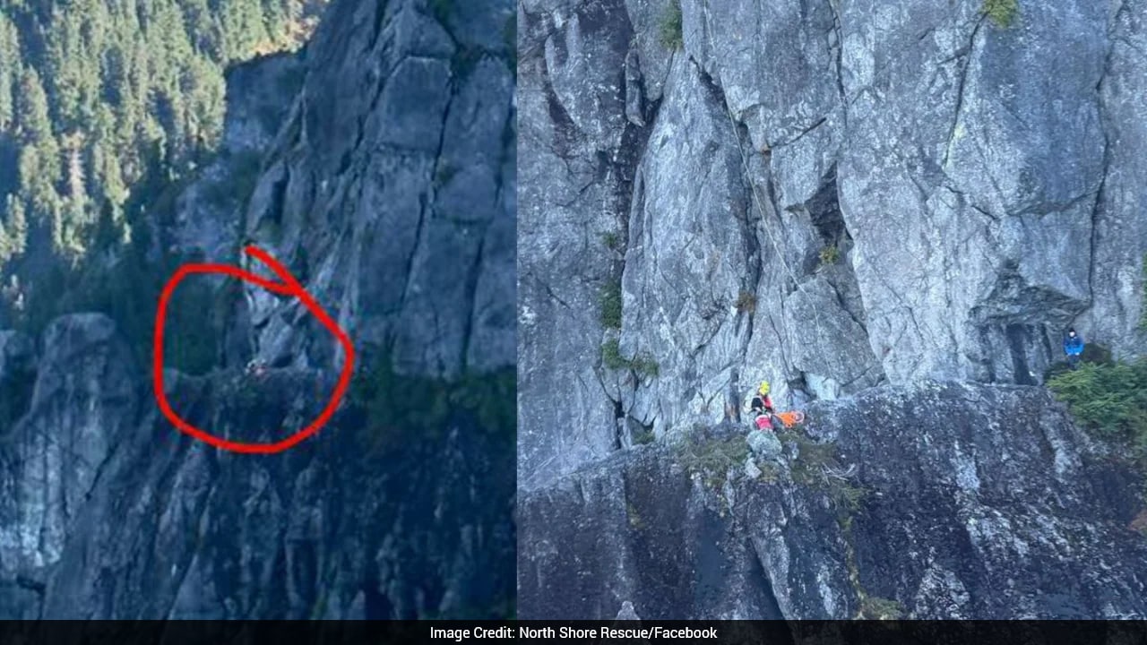
A sixteen-year-old hiker in British Columbia recently found himself clinging to a vertical limestone ledge as darkness fell, waiting for search and rescue teams after an unverified navigation application generated a route straight through a sheer cliff face.
The incident is not an isolated anomaly of backcountry panic. It is the predictable outcome of treating complex topography as a mere graph problem to be solved by consumer software. When automated routing engines encounter wilderness, they do not see vertical drops, loose scree, or impenetrable thickets of devil's club. They see coordinates, vector lines, and theoretical paths. Also making news in related news: Inside the H-1B Visa Crackdown That Hit Microsoft and Exposed Corporate Labor Arbitrage.
Technology has democratized access to the outdoors while simultaneously stripping away the friction that once forced hikers to develop basic competence. Millions of casual outdoor enthusiasts now head into remote terrain armed with nothing more than a smartphone subscription and misplaced faith in automated mapping agents. The result is a quiet crisis across North American trail networks where search and rescue volunteers are increasingly deployed not to find lost wanderers, but to extract digital disciples from self-inflicted traps.
The Illusion of Safety Behind a Glass Screen
Generative route planners and consumer mapping platforms aggregate geographic data from varied sources, ranging from official park registries to crowdsourced uploads by anonymous users. This data is then processed through routing algorithms designed to optimize for distance, elevation gain, or user preference metrics like scenic views or fast completion times. Additional insights into this topic are explored by The Verge.
The machine optimization process creates a dangerous illusion of objective truth. When a user sees a highlighted line on a smartphone screen, the brain registers it as an authorized, vetted corridor.
Real-world geography resists clean categorization. A trail designation in a municipal park means a maintained path with wooden bridges and gravel beds. A trail designation in a rugged provincial park or federal wilderness area might mean an abandoned logging road, a historical trapping route washed out by a decade of spring runoffs, or a faint game trail used primarily by mountain goats.
Algorithms lack the contextual intelligence to differentiate between these realities. If two GPS coordinates sit three miles apart across a glacial ravine, the routing script draws a straight vector and labels it a connecting segment. It does not account for the vertical rock wall, the rushing glacial meltwater, or the dense timber blowdown that makes physical transit impossible for an unequipped teenager with a daypack.
The Erosion of Foundational Field Craft
For generations, outdoor safety relied on physical navigation tools and conservative risk assessment. Map reading, compass work, terrain association, and route finding were prerequisites for leaving the trailhead. These skills demanded patience, sustained attention, and an intimate understanding of topography. Contour lines on a topographic map do not just show elevation change; they tell a story about the steepness of a slope, the presence of cliffs, and the feasibility of an ascent.
Smartphone mapping applications short-circuit this educational pipeline. By reducing navigation to a glowing blue dot moving across a raster image, applications remove the need for spatial awareness.
Hikers no longer look up to read the landscape. They stare down at a screen, matching their physical position to a digital icon rather than identifying surrounding ridgelines, peaks, or watersheds. When the application fails or directs them off course, the psychological shock is profound. Without the foundational ability to look at the terrain and deduce a safe escape route, users experience paralysis. They press forward into increasingly dangerous terrain because the application insists the destination is just a few hundred yards ahead.
This dependency creates a cascading failure loop. A minor navigational error becomes a major emergency simply because the victim lacks the diagnostic tools to recognize they are on the wrong path until physical escape routes have vanished.
The Liability Vacuum of Digital Guides
The software companies building and marketing these routing tools operate in a regulatory gray zone. Unlike traditional guidebook publishers, who often employ local experts, fact-checkers, and field researchers to verify routes, consumer tech platforms rely on automated data scraping and user-generated content moderation.
When a guidebook makes a dangerous error, accountability can sometimes be traced through editorial pipelines. When an algorithm hallucinates a traversable path across a cliff face by synthesizing incomplete satellite imagery and erratic user telemetry, the company behind the interface points to a terms-of-service disclaimer absolving them of liability for outdoor injuries or death.
The commercial incentive structure actively encourages aggressive routing. Applications compete on feature sets that promise to help users discover hidden gems, secret viewpoints, and off-the-beaten-path adventures. By marketing the untamed wilderness as a playground for frictionless exploration, these platforms obscure the inherent risks of backcountry travel. They sell convenience in an environment where convenience is fundamentally antithetical to survival.
Rebuilding Wilderness Competence
Addressing the rise of algorithmic rescues requires more than minor tweaks to user interfaces or the addition of standard warning popups that users habitually tap away. It demands a cultural shift in how outdoor recreation is marketed and consumed.
First, mapping platforms must implement strict hazard boundaries within their routing logic. Automated engines should be programmed to restrict route generation in designated wilderness areas to established, maintained trail systems rather than attempting to synthesize off-trail paths from raw spatial data.
Second, outdoor education needs to be integrated into the purchase and download process for wilderness technology. If an application is used to download offline maps for a remote region, the software should require users to pass basic competency checks or review mandatory safety protocols regarding terrain assessment and emergency turnaround times.
Finally, individuals must reclaim a healthy skepticism toward digital convenience. The wilderness does not recognize software updates, and topography does not care about optimal routing parameters. Until outdoor enthusiasts learn to trust their own eyes and judgment over the glowing recommendations of a server farm, cliff rescues involving smartphone-dependent hikers will remain a grim fixture of the modern adventure economy.