Flash flood watches across the Gulf Coast signify more than a temporary meteorological event; they represent a systemic failure where atmospheric moisture transport outpaces municipal drainage capacity. When millions of residents across Louisiana face imminent inundation warnings, the underlying crisis is driven by three intersecting variables: precipitable water efficiency, low-gradient topography, and structural deficits in civil infrastructure. Minimizing the economic and human toll requires analyzing these factors not as isolated incidents of severe weather, but as a predictable hydrological cost function.
Understanding this crisis requires isolating the specific mechanisms that transform routine atmospheric shifts into catastrophic localized events.
The Thermodynamic Drivers of Flash Flood Generation
The primary catalyst for severe rainfall along the Gulf Coast is the stagnation of tropical air masses characterized by extraordinarily high precipitable water (PW) values. Precipitable water represents the total atmospheric water vapor contained in a vertical column above a given point. When PW values exceed the climatological mean for the region—often climbing above 2.0 inches—the atmosphere becomes highly efficient at converting updrafts into high-velocity precipitation.
[High Precipitable Water (>2.0 inches)] + [Atmospheric Stagnation]
                      ↓
          [High-Velocity Precipitation]
                      ↓
     [Saturated Low-Gradient Topography]
                      ↓
          [Systemic Flash Flooding]
This efficiency increases exponentially due to the Clausius-Clapeyron relation, which dictates that the water-holding capacity of the atmosphere increases by approximately 7% for every 1°C of warming. In Louisiana, this thermodynamic principle manifests as convective rain bands that lock into place. Unlike fast-moving frontal systems that distribute rainfall across vast geographic areas, these slow-moving training storms repeatedly dump water over the same drainage basins within compressed timeframes.
The immediate consequence is a failure of the initial abstraction phase of the hydrological cycle. In standard models, a portion of initial rainfall is absorbed by canopy interception, surface depression storage, and soil infiltration. When precipitation intensity exceeds 2 to 3 inches per hour, the infiltration capacity of the soil is surpassed within minutes, regardless of prior soil moisture conditions. The system transitions almost immediately to a state of 100% surface runoff generation.
The Topographical Bottleneck and Low-Gradient Hydrology
Once rainfall transforms into surface runoff, Louisiana’s specific geomorphology compounds the volume of water. The state’s coastal plain is characterized by an exceptionally low hydraulic gradient. In many regions, the elevation changes by less than a few feet over several miles.
This lack of topographic relief severely limits the natural velocity of sheet flow and channelized flow. Gravity-driven drainage relies on a slope to move water away from vulnerable human settlements toward larger receiving bodies, such as the Gulf of Mexico or the Mississippi River basin. When the slope approaches zero, the velocity of the water drops, causing the discharge rate of local bayous, canals, and rivers to plummet.
The problem is worsened by backwater effects. When main river channels experience elevated stages due to regional precipitation, their water levels rise higher than the tributary drainage ditches and municipal outfalls feeding into them. Instead of draining, water flows backward up the system or pools at the confluence points. This creates a hydraulic damming effect that forces water to expand laterally into residential and commercial zones, transforming minor urban creeks into major flood vectors.
The Urban Cost Function and Infrastructure Decay
Urbanization modifies the natural hydrograph by replacing permeable soils with impervious surfaces like asphalt, concrete, and roofing. This structural shift alters the runoff dynamics in two distinct ways:
- Peak Flow Acceleration: Runoff reaches municipal drainage networks in a fraction of the time it would take in a forested or agricultural catchment. The peak discharge occurs faster and with greater volume, compressing the window for emergency management interventions.
- Total Volume Expansion: Without soil infiltration, the total volume of water entering the civil infrastructure network matches the total volume of precipitation minus minor evaporation losses.
Louisiana’s urban centers operate on aging stormwater management systems designed under historical rainfall assumptions that no longer align with current meteorological realities. Many municipal drainage networks are engineered to handle a "10-year storm event"—a metric based on historical probabilities that assumes a specific rainfall intensity will only occur once a decade. Current atmospheric trends show these thresholds are breached with far greater frequency.
When a drainage system rated for 1.5 inches of rain per hour is subjected to 3.5 inches per hour, the system enters a state of hydraulic surcharge. Water backs up through catch basins and manholes because the sub-surface pipes lack the cross-sectional area to transport the volume under gravity alone. The cost function of this failure is borne directly by local economies through asset destruction, business interruption, and supply chain stagnation along major shipping and freight corridors.
Risk Stratification and Vulnerability Metrics
Evaluating the true threat of a flash flood event requires distinguishing between hazard and vulnerability. The hazard is the physical volume and velocity of the water; the vulnerability is the socio-economic framework exposed to that hazard. In Louisiana, vulnerability is heavily stratified by geographic isolation and structural wealth disparities.
Vulnerability Index = f(Elevation, Infrastructure Age, Socio-Economic Mobility)
Low-income communities are frequently situated in lower-elevation tracts that were historically cheaper to develop but are highly prone to chronic inundation. These areas often feature older infrastructure that receives less preventative maintenance, such as regular clearings of debris and sediment from drainage culverts.
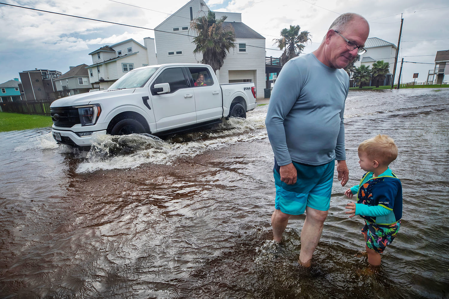
The second limitation involves institutional emergency response capabilities. Evacuation requires liquid capital, functional transport assets, and secure destinations. When flash flood watches are issued with short lead times, the window for organized displacement closes rapidly. Residents in high-vulnerability zones are forced to shelter in place within structures that may not possess the vertical elevation necessary to survive severe structural flooding.
Strategic Mitigations and Hydrological Realignment
Traditional flood mitigation relies on gray infrastructure—concrete sea walls, levees, and ever-larger pumping stations. While these engineering solutions are necessary for high-density urban nodes like New Orleans, they are capital-intensive, slow to deploy, and prone to catastrophic failure modes if design thresholds are exceeded.
A resilient strategy requires a shift toward decentralized hydrological management, often termed "living with water." This methodology integrates green infrastructure to restore a portion of the landscape's natural storage capacity.
- Retention and Detention Basins: Constructing managed wetlands and dry-extended detention ponds within urban perimeters to temporarily hold peak runoff volumes, releasing the water at a controlled rate after the atmospheric event passes.
- Permeable Pavements and Urban Greenways: Replacing non-critical impervious surfaces with porous media to re-establish localized infiltration pathways.
- Braid Channels and Bioswales: Designing engineered linear channels filled with vegetation to slow the velocity of overland flow, reducing the peak height of the flood wave down-gradient.
On a macro level, state and local authorities must overhaul building codes and zoning laws. Continuing to permit slab-on-grade residential construction in historical floodplains guarantees future economic losses. Mandating open-foundation pier construction for new structures in high-risk zones alters the risk profile by allowing water to pass beneath the living space without compromising the structural integrity of the asset.
The immediate outlook for Louisiana underscores a structural reality: atmospheric dynamics will continue to deliver high-volume moisture inputs to the Gulf Coast. Municipalities that fail to transition from a reactive emergency posture to a proactive structural and hydrological redesign will face compounding financial liabilities. True systemic resilience lies in altering the physical footprint of the built environment to accommodate inevitable volume spikes rather than pretending they can be permanently engineered away.