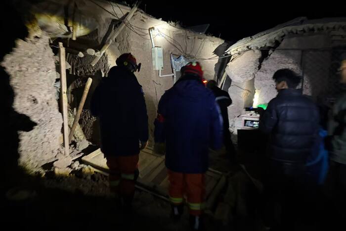
Headlines pairing a magnitude 7.0 earthquake with a raw casualty count and dramatic video clips compress a complex physical and operational event into a single shock reaction. To understand why a major tremor on the Tibetan Plateau produces a specific toll—and why early counts shift—readers need a framework that separates ground motion physics, structural vulnerability, altitude constraints, and information latency. This analysis deconstructs the headline logic behind high-magnitude Tibet earthquakes and replaces sensational framing with an operational model of seismic risk, casualty drivers, and response bottlenecks.
Deconstructing the Competitor Headline Logic
A headline announcing a 7.0 earthquake in Tibet, a tally of 16 deaths, and terrifying CCTV footage operates on three implicit assumptions that distort how audiences interpret risk.
- Magnitude equals uniform destruction: Readers often equate a 7.0 reading on a moment magnitude scale with a fixed radius of catastrophic ruin. In reality, magnitude measures total seismic energy released at the source, whereas actual damage depends on rupture depth, fault geometry, directivity, local soil amplification, and building stock.
- Early death tolls represent final impact: Initial casualty figures reported alongside breaking video clips are snapshots captured before communications are restored across remote valleys and high-altitude townships. Reporting a single number as if it were a static ledger obscures the difference between confirmed recoveries and unverified missing persons.
- CCTV footage explains systemic risk: Surveillance video provides immediate proof of ground shaking and human panic, yet camera angles are biased toward monitored urban or commercial interiors. Footage rarely shows rural masonry failure, highway rockfalls, or lifeline infrastructure outages where the highest operational friction occurs.
Examining the cause-and-effect chain reveals where standard breaking coverage stops short. Strong shaking triggers structural or slope failure; structural failure interacts with local construction materials and population density; altitude and distance govern rescue speed; and rescue speed determines whether treatable injuries become fatalities. A headline that stops at magnitude, video drama, and an early headcount leaves the mechanics of survival unexplained.
The Seismic Mechanics of the Tibetan Plateau
The Tibetan Plateau sits above the ongoing continental collision between the Indian tectonic plate and the Eurasian plate. This convergence drives crustal shortening, uplift, and strike-slip and thrust faulting across a vast high-elevation region. Because the crust beneath parts of the plateau is thick and thermally complex, strain accumulates across major fault systems and releases through periodic earthquakes that can reach magnitude 7.0 or higher.
When evaluating a 7.0 event in this setting, analysts separate source physics from site effects:
- Moment magnitude versus peak ground acceleration: A magnitude 7.0 rupture releases roughly 32 times more energy than a magnitude 6.0 event (following standard logarithmic scaling of seismic moment), yet peak ground acceleration at a given town depends heavily on distance to the fault plane and whether rupture propagation focuses energy toward that settlement.
- Focal depth and wave attenuation: Shallow crustal earthquakes typically generate stronger surface waves and localized shaking intensity than deep events of equal magnitude, while complex mountain topography can scatter seismic waves and amplify shaking on ridges or unconsolidated basin sediments.
- Secondary geohazards: Steep slopes, freeze-thaw fractured rock, and permafrost or glacial terrain mean ground shaking frequently triggers rockfalls, landslides, and road blockages that isolate communities even when some buildings remain standing.
Distinguishing known geological mechanisms from event-specific hypotheses is essential when exact post-event telemetry is still being compiled. The general tectonic driver—Indo-Eurasian convergence accommodating crustal deformation—is an established scientific fact. By contrast, any claim about exact casualty distribution, specific building collapse rates, or whether a particular valley faces secondary damming or aftershock clustering remains a hypothesis until verified by seismological networks and on-the-ground engineering assessments.
The Four Pillars of Casualty and Damage Dynamics
When a major earthquake strikes a high-altitude region like Tibet, human and physical losses are governed by four interacting pillars rather than magnitude alone.
1. Exposure and Settlement Dispersion
Population density across the Tibetan Plateau is uneven, concentrated in valley floors, agricultural pockets, and administrative towns separated by vast sparsely populated expanses. A magnitude 7.0 rupture centered in an unpopulated high basin can cause severe geological deformation with relatively low direct building exposure, whereas rupture near a denser town or along a transport corridor multiplies exposure immediately.
2. Structural Typology and Load Paths
Building performance hinges on lateral force resistance. Unreinforced masonry, heavy earthen or stone walls, and older structures without ductile confinement perform poorly under cyclic horizontal shear forces. Even moderate ground shaking can cause brittle wall failure or roof collapse if roofs are heavy and walls lack tie beams or adequate shear capacity.
3. Altitude and Physiological Friction
Operating at high elevation alters both human resilience and emergency logistics. Thin air reduces oxygen availability, increasing physical strain and slowing work rates for rescue teams, medical personnel, and displaced residents exposed to subzero night temperatures. Cold stress turns delayed extrication into a compounding threat: someone trapped under debris faces not only crush injury or hemorrhage, but hypothermia.
4. Lifeline and Corridor Fragility
High-mountain geography concentrates transport and power into narrow corridors—mountain passes, river gorges, bridges, and single-line roads. A single landslide or bridge failure can sever ground access to an entire county, forcing reliance on helicopters that are themselves constrained by high-density altitude, wind gusts, and weather windows.
Information Latency and the Casualty Accounting Gap
Early reporting on earthquakes routinely exhibits a lag between physical reality and verified public tallies. In rugged terrain, cellular backhaul, grid power, and local administrative reporting channels can fail simultaneously.
The first casualty figure in a breaking report usually reflects confirmed deaths reported by nearby hospitals or initial local responders within the first hours. A second, often higher phase emerges as search-and-rescue teams reach outlying villages and clear rubble. A third adjustment—sometimes downward or reclassified—occurs when duplicate reports are reconciled or missing-person lists are cross-checked against evacuated residents.
Analytical Rule: Treat initial post-earthquake casualty numbers as a lower bound of confirmed reports at a specific timestamp, not as a completed census of harm.
Video clips from CCTV cameras play a distinct role in this timeline. They compress emotional salience into a few seconds, showing shelves toppling, lights swinging, or people running for cover. Yet visually compelling footage does not measure structural integrity across a district. A single dramatic clip can anchor audience attention on one location while severe damage goes unfilmed ten miles away along an unmonitored road.
Tactical Framework for Evaluating Seismic Response
For risk analysts, emergency planners, or informed readers tracking a major earthquake in real time, a disciplined sequence prevents over-indexing on headlines and points toward actionable operational questions.
- Establish the rupture profile: Check authoritative seismological agencies for moment magnitude, depth, fault mechanism, and shaking intensity maps (such as modified Mercalli or instrumental intensity) rather than relying on initial social media estimates.
- Map exposure against intensity: Overlay shaking contours onto settlement locations and transport routes to separate high-shaking zones with low population from moderate-shaking zones containing older buildings or steep slopes.
- Track lifeline status before headcounts: Monitor road passability, bridge integrity, power restoration, and communications uptime. Access bottlenecks predict how fast medical care and shelter supplies can reach affected clusters.
- Separate confirmed fatalities from unverified impact: Watch how authorities distinguish confirmed recoveries from ongoing search operations, and account for nighttime temperatures and weather when estimating secondary survival risk.
- Anticipate aftershock sequences: Major crustal earthquakes are followed by aftershocks that pose ongoing danger to weakened structures and responders working inside damaged buildings.
Operational Limitations and Uncertainties
Even a rigorous analytical framework has hard boundaries during an active crisis. Satellite imagery can spot large landslides and collapsed structures, yet cloud cover, steep canyon shadows, and resolution limits can obscure smaller buildings or narrow trails. Seismic early warning systems can buy seconds of alert where dense sensor networks exist, but they cannot prevent structural failure in vulnerable buildings or eliminate terrain hazards.
Similarly, no single operational lever solves high-altitude disaster response. Helicopters bypass blocked roads but carry smaller payloads and face strict high-altitude performance limits; heavy machinery clears debris quickly but requires passable routes and fuel supply chains; rapid shelter reduces cold exposure but depends on staging inventory before winter storms hit. Every response choice involves trade-offs between speed, weight, safety, and coverage.
Strategic Play
When evaluating or managing exposure to high-altitude seismic events like a magnitude 7.0 earthquake in Tibet, shift resources and attention away from headline magnitude and dramatic video clips toward pre-positioned structural reinforcement, redundant lifeline corridors, and cold-weather rapid-response readiness. In high-elevation environments where terrain and temperature punish delay, reducing building collapse risk and keeping access routes open before the tremor strikes delivers far higher expected value than reacting after roads are cut and night temperatures fall.