The transition of a military search operation from a search-and-rescue status to a search-and-recovery phase represents a mathematical pivot point where the probability of survival matches or falls below environmental and physiological survival thresholds. When a U.S. Marine assigned to the 13th Marine Expeditionary Unit went missing from the amphibious transport dock ship USS Anchorage off the Southern California coast at 1:20 a.m. on Thursday, June 25, 2026, it triggered a multi-agency, multi-domain search matrix. By Friday evening, after 43 hours of continuous operations covering 2,400 square miles, the U.S. Navy 3rd Fleet shifted its operational objective. Understanding this transition requires examining the strict operational mathematics, environmental physics, and search-theory models that govern open-ocean tracking.
Optimizing open-ocean operations relies on a predictive calculus designed to maximize probability of detection before physiological limits are reached. When a man-overboard or missing personnel incident occurs during integrated training—such as the exercises conducted between the 13th MEU and the Makin Island Amphibious Ready Group—the response cannot rely on manual scouting. Instead, commanders deploy structured frameworks to allocate finite aviation and surface assets against a rapidly expanding search area.
The Kinematic Trajectory and Drift Mechanics
The primary complication of an open-ocean missing person incident is the compounding expansion of the search area over time. The datum—the last known position of the individual—immediately begins to blur due to two distinct environmental forces acting on the subject.
- Total Water Current (TWC): The combination of tidal currents, sea-surface drift, and local wind-driven currents that physically transport a floating object through the water column.
- Leeway Drift: The movement of an object through the water caused by the wind blowing directly against the exposed surface area of that object.
For a human body in the water, the leeway speed is highly variable depending on whether the individual is wearing a life jacket, an immersion suit, or standard utility uniforms. The U.S. Coast Guard uses empirical leeway equations where leeway speed is modeled as a linear function of wind speed:
$$U_L = m \cdot U_{10} + b$$
Where $U_L$ is the leeway speed, $U_{10}$ is the wind speed at 10 meters above the surface, $m$ is the multiplier representing the percentage of wind speed transferred to the object, and $b$ is a constant offset. For a person in the water in a defensive survival posture, $m$ is low, but over hours, even a minor variance in the current vector shifts the true location miles away from the initial datum.
The total search area grows exponentially rather than linearly. If an asset cannot arrive within the initial window, the search radius expands according to the square of elapsed time ($t^2$). This kinematic expansion creates an immediate resource bottleneck: as the area increases, the density of coverage drops unless additional aircraft or surface vessels are integrated into the grid.
Multi-Domain Asset Allocation and Sensor Arrays
The mobilization of 12 aircraft and three surface ships from the Navy, Marine Corps, Air Force, and Coast Guard demonstrates the asset-density requirement of high-probability search grids. Asset allocation is managed via computerized search tools that maximize the Probability of Detection (POD), which is mathematically defined as:
$$\text{POD} = P_C \cdot P_D$$
Where $P_C$ is the Probability of Containment (the mathematical probability that the target is actually inside the designated search area) and $P_D$ is the Probability of Discrimination (the likelihood that a specific sensor will detect the target given that it is inside the area).
The 12 aircraft deployed in this sector utilized distinct sensor suites to optimize detection across different wavebands:
- Forward-Looking Infrared (FLIR): Thermal imaging systems that detect temperature differentials between the human body and the surrounding ocean. In the Pacific waters off Southern California, water temperatures generally range from 58°F to 64°F, which typically provides a distinct thermal contrast against a 98.6°F body. However, thermal signature degradation occurs rapidly due to hypothermia, which lowers core and surface body temperature, and sea spray, which masks thermal emissions.
- Optical and Visual Reconnaissance: Low-altitude search patterns where crews use night-vision goggles (NVGs) during nocturnal windows and high-magnification optics during daylight. Visual searches are severely limited by sea state; waves greater than three feet can physically obscure a floating subject from view at standard search altitudes.
- Radar Systems: Maritime surveillance radars deployed on fixed-wing assets can detect small targets on the ocean surface, but their efficacy is limited by "sea clutter"—radar reflections from wave crests that generate false positives in high-wind conditions.
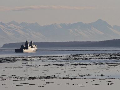
Surface vessels, including the USS Anchorage and accompanying Coast Guard cutters, act as coordination nodes and execute localized creeping line or sector search patterns. These ships maintain continuous sonar and visual watches while serving as recovery platforms for the aviation assets operating overhead.
Physiological Thresholds and the Recovery Pivot
The decision to transition from search-and-rescue to search-and-recovery is governed by empirical survival data rather than administrative timelines. The human body faces two primary physiological failures when immersed in open ocean water without specialized thermal protection: hypothermia and drowning due to exhaustion.
In water temperatures below 70°F, heat loss occurs approximately 25 times faster than in air of the same temperature. The progression of hypothermia under these conditions follows a predictable timeline:
- Cold Shock Response (0 to 3 minutes): Immediate hyperventilation and elevated heart rate upon immersion, which increases the risk of inhaling water.
- Swim Failure (10 to 30 minutes): Rapid cooling of extremities leads to a loss of neuromuscular control. The individual loses the coordination required to swim or maintain a clear airway, even if they are an elite athlete or military survival swimmer.
- Hypothermia and Unconsciousness (2 to 12 hours): Core body temperature drops below 95°F, leading to cognitive decline, followed by loss of consciousness as core temperature falls below 86°F.
The 43-hour window executed by the joint command far exceeded the standard physiological threshold for survival in uninsulated coastal waters. Once the elapsed time surpasses the upper limit of human survival models, the mathematical objective shifts. Search parameters are adjusted away from rapid extraction toward systematic recovery tracking, altering the altitude, speed, and sensor configuration of the remaining assets to account for a passive, submerged, or non-responsive target.
Strategic Operational Limitations
While the deployment of multi-agency assets achieves a high degree of area coverage, the framework contains inherent operational limitations. Predictive drift software relies heavily on real-time marine meteorological data. Mid-frequency coastal currents off the California coast are highly complex due to the collision of the California Current with localized counter-currents and underwater topography near the Channel Islands. If local weather buoys fail to capture micro-scale eddy currents, the baseline drift vectors used to build the search grid will deviate from reality, misaligning the asset deployment zone.
Furthermore, air-sea integration requires precise inter-agency communications. Operating aircraft from three separate military branches alongside Coast Guard assets in a compressed airspace requires rigid air traffic management and introduces data-sharing delays. Sensor telemetry from an Air Force asset must be processed, transmitted to the Navy’s regional command center, and translated into actionable coordinates for Navy or Coast Guard surface vessels, introducing a systemic latency that can affect real-time search adjustments.
The operational focus shifts completely to the ongoing investigation into the causal chain of the initial man-overboard event. Naval safety boards use structured mishap investigation frameworks to analyze mechanical failures, structural lighting deficiencies during night operations, watch-standing protocols, and individual equipment configurations aboard the USS Anchorage. The data gathered from the 2,400-square-mile search matrix will be preserved to refine future drift-model algorithms, ensuring that the interface between predictive kinematics and real-world asset allocation is systematically improved for subsequent maritime deployments.


