The occurrence of a magnitude 6.7 shallow crustal earthquake in Central Sulawesi highlights a structural vulnerability profile that standard seismic modeling frequently miscalculates. While a magnitude 6.7 event is moderate in raw energy release compared to megathrust events, its superficial focal depth of approximately 10 kilometers amplifies ground acceleration along local fault lines.
When analyzing localized seismic events, the primary determinant of destruction is not the absolute magnitude on the moment magnitude scale, but rather the localized peak ground acceleration combined with regional geomorphology and built-environment resilience. The 2026 Sulawesi event serves as a critical baseline for evaluating the secondary risk cascades that threaten regions with high historical trauma and fragmented structural infrastructure.
The Kinematics of Shallow Crustal Rupture
The tectonic framework of Sulawesi is governed by complex convergence zone mechanics involving the Philippine Sea, Australian, and Sunda plates, intersected by localized strike-slip systems such as the Palu-Koro fault system. The seismic event on June 16, 2026, originated at an epicenter roughly 42 to 46 kilometers east-southeast of Palu.
Understanding the destructive potential of this specific event requires isolating three mechanical variables that define shallow crustal ruptures.
- Focal Depth Proximity: At a shallow depth of 10 kilometers, the seismic wave attenuation distance is highly compressed. Energy reaches the surface with minimal geometric spreading, resulting in high-frequency ground shaking that directly targets low-to-medium rise engineered structures.
- Aftershock Frequency Decay: The mainshock was rapidly followed by an aftershock sequence featuring magnitudes of 5.2, 5.0, and 4.9. In a compromised built environment, these high-frequency subsequent events introduce cumulative structural fatigue, triggering collapses in buildings that survived the initial wave front.
- Wave Duration Metrics: Reports indicating sustained strong shaking lasting for over 60 seconds in Palu demonstrate that the rupture duration or local site amplification prolonged the cycles of loading on foundations. This duration is long enough to initiate liquefaction in highly susceptible, saturated alluvial soils.
Structural and Operational Strain Diagnostics
The immediate societal reaction to the earthquake revealed critical operational vulnerabilities across public infrastructure. The evacuation of facilities like the Samaritan Hospital in Palu underscores a persistent challenge in disaster management: the non-structural failure of critical healthcare hubs.
Hospitals and high-occupancy structures must be evaluated through a dual-lens framework consisting of structural integrity and operational continuity.
                  [ Seismic Wave Front Entry ]
                              │
             ┌────────────────┴────────────────┐
             ▼                                 ▼
   [ Structural Systems ]            [ Non-Structural Systems ]
   • Foundations & Columns           • Unbraced Medical Equipment
   • Load-Bearing Masonry            • Utilities & IV Drip Lines
   • Rigid Concrete Frames           • Emergency Triage Tents
The evacuation of patients into open air spaces, while necessary to mitigate the risk of injury from falling masonry or structural collapse, instantly breaks the operational continuity of medical systems. The reliance on outdoor triage tents indicates that internal non-structural components—such as ceiling tiles, unbraced medical gear, and fluid delivery systems—either failed or were deemed too high-risk to remain near during the aftershock decay cycle.
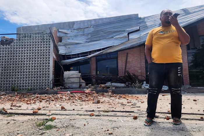
In neighboring Sigi, where at least eight injuries occurred, structural damage manifested as partially collapsed roofs and shattered walls. This specific damage pattern points to a failure in the structural connection between wall elements and roof trusses, a common vulnerability in non-engineered or semi-engineered brick masonry homes common across the region.
The Psychological Multiplier and Tsunami Risk Realities
A significant variable shaping the economic and operational response to the 2026 event is the psychological trauma stemming from the catastrophic 2018 magnitude 7.5 earthquake and subsequent tsunami. Spontaneous mass migration away from coastal zones occurred despite immediate modeling from Indonesia's Meteorology, Climatology, and Geophysics Agency confirming zero tsunami risk.
From a physics perspective, the absence of a tsunami hazard in this instance is straightforward:
$$\text{Tsunami Risk} \propto f(\text{Vertical Seafloor Displacement})$$
The June 2026 event occurred inland, centered more than 40 kilometers from the coast, meaning it lacked the submarine dip-slip or thrust mechanism required to displace a critical volume of the water column. However, human behavioral patterns in seismic zones do not follow real-time algorithmic alerts. The immediate flight to high ground creates localized transit bottlenecks, disrupting emergency vehicle routing and complicating the deployment of search and rescue teams.
Regional Scaling and Damage Assessment Gaps
A core challenge in the immediate aftermath of regional seismic events is the data asymmetry between urban centers and rural regencies. While real-time reports emerged quickly from Palu due to high cellular density and intact communication infrastructure, three surrounding regencies encompassing a population baseline of approximately 1.2 million remained unassessed during the initial critical hours.
This operational blind spot is a function of the infrastructure dependencies of modern telemetry. When local power grids experience automated trips to prevent electrical fires during shaking, telemetry stations and cellular transceivers rely on limited backup battery systems. Consequently, the regions closest to the epicenter are frequently the ones that fall silent first, creating a dangerous inversion where emergency resource allocation is guided by where data is available, rather than where the damage is most severe.
Engineering Resiliency Protocols for High-Risk Fault Zones
Mitigating the long-term economic and human toll of events of this magnitude requires moving away from reactive post-disaster distribution models and adopting rigorous engineering asset management strategies.
First, municipal building codes must mandate base-isolation or flexible joint detailing for all essential public service facilities within 50 kilometers of known active fault lines. Standard rigid concrete designs perform poorly under the rapid, high-frequency shear waves characteristic of 10-kilometer-deep crustal events.
Second, regional disaster mitigation frameworks must implement predictive structural health monitoring networks. By installing low-cost accelerometers across high-occupancy public buildings, civil defense teams can immediately identify non-visible structural degradation following a mainshock, removing the ambiguity surrounding whether a building is safe to re-occupy before the aftershock sequence concludes.
Central Sulawesi Governor Anwar Hafid's activation of immediate structural inspections by technical teams marks a step toward formalized risk management. However, these inspections must be codified into automated protocols rather than deployed as ad-hoc political directives. The baseline objective must be the creation of real-time structural risk maps that quantify building safety metrics before public or commercial operations are permitted to resume.