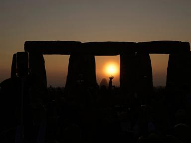
The astronomical phenomenon colloquially termed the summer solstice is not a day-long event but a singular orbital coordinate. This coordinate dictates a peak in Northern Hemisphere solar irradiance, establishing a baseline for global climate models, agricultural cycles, and structural energy loads. Understanding this event requires moving past the cultural narrative of "the longest day of the year" and examining the geometric and thermodynamic frameworks that govern planetary insolation.
The Geometric Framework of Obliquity
The primary driver of seasonal variance is Earth's axial tilt, or obliquity, which sits at approximately $23.5^\circ$ relative to its orbital plane (the ecliptic). During the June solstice, the Northern Hemisphere reaches its maximum inclination toward the Sun.
This spatial orientation produces three distinct geographic boundaries:
- The Tropic of Cancer ($23.5^\circ\text{ N}$): The latitude where solar rays strike the Earth at a perpendicular angle ($90^\circ$) at local solar noon. This maximizes the solar flux density per unit area.
- The Arctic Circle ($66.5^\circ\text{ N}$): The southern boundary of the region experiencing a continuous 24-hour photoperiod, where the sun does not dip below the horizon.
- The Antarctic Circle ($66.5^\circ\text{ S}$): The northern boundary of continuous polar night, marking the absolute minimum of solar input for the Southern Hemisphere.
The misconception that the solstice correlates with the closest proximity to the Sun ignores orbital eccentricity. Earth reaches perihelion (closest approach) in January and aphelion (farthest approach) in July. The June solstice occurs near aphelion, demonstrating that axial orientation, not orbital distance, governs regional thermal energy distribution.
The Photoperiod Gradient and Latitude Scaling
The duration of daylight on the solstice is a direct function of latitude, governed by the spherical geometry of the planet. As latitude increases northward from the equator, the proportion of the diurnal circle illuminated by the Sun expands.
Latitude vs. Solstice Daylight Duration (Approximated)
0° (Equator)        : 12 hours, 0 minutes
20° N               : 13 hours, 21 minutes
40° N (New York)    : 15 hours, 1 minute
60° N               : 18 hours, 52 minutes
66.5° N to 90° N    : 24 hours, 0 minutes
At the equator, the photoperiod remains virtually invariant at 12 hours year-round because the terminator line (the division between night and day) always bisects the equator precisely. Moving northward, the curvature of the Earth causes the terminator line to intersect latitudes at increasingly oblique angles.
The mathematical relationship determining the hour angle of the sun at sunrise or sunset ($\omega_s$) is expressed through the solar declination ($\delta$) and the observer's latitude ($\phi$):
$$\cos(\omega_s) = -\tan(\phi) \tan(\delta)$$
During the June solstice, the solar declination $\delta$ is exactly $+23.5^\circ$. When evaluating this equation for latitudes above $66.5^\circ\text{ N}$, the product of $\tan(\phi)\tan(\delta)$ exceeds 1, rendering the equation insoluble via standard real numbers, which physically represents the absence of a sunset.
Atmospheric Attenuation and the Insolation Paradox
A critical distinction must be made between top-of-atmosphere (TOA) insolation and surface-level solar irradiance. While the North Pole receives the highest total TOA insolation over a 24-hour period on the solstice—surpassing the equator due to continuous exposure—it does not experience the highest surface temperatures.
Two main factors cause this discrepancy:
- The Path Length of Solar Radiation (Air Mass Coefficient): At high latitudes, the sun remains low on the horizon. Solar radiation must traverse a significantly thicker cross-section of the atmosphere. This extended path length increases scattering by aerosols, molecules, and clouds, reducing the net energy reaching the surface.
- Surface Albedo: The polar regions retain snow and ice cover well into the summer. These surfaces reflect up to 80% of incoming solar radiation back into space, compared to open ocean or dark soil, which absorb over 90% of incident thermal energy.
The Thermodynamic Lag Function
A common source of confusion is the disconnect between the date of maximum solar irradiance (the solstice) and the peak temperatures of the summer season, which typically occur four to six weeks later in July or August. This delay is explained by the thermodynamic principle of thermal inertia.
The Earth system acts as a massive thermal reservoir, dominated by the heat capacity of the oceans. Liquid water requires 4,184 Joules of energy to raise the temperature of one kilogram by one degree Celsius.
During the weeks following the solstice, the net energy input into the Northern Hemisphere continues to exceed the net infrared radiation emitted back into space. The system remains in a state of positive net radiation balance. Temperatures continue to climb until the diminishing daily photoperiod forces the outgoing longwave radiation to equal, and eventually surpass, incoming solar shortwave radiation.
Infrastructure and Economic Dependencies
The sudden shift to peak daylight hours directly affects modern infrastructure networks, creating predictable system strains that require active management.
Power Grid Management
The solstice marks the transition into peak cooling loads for electrical grids across the Northern Hemisphere. While solar photovoltaic (PV) generation capacity reaches its annual theoretical maximum due to the extended day length, high ambient temperatures decrease the operational efficiency of solar panels. Silicon-based PV cells experience a drop in voltage output as temperatures rise above $25^\circ\text{ C}$, meaning the day of maximum daylight does not necessarily yield the day of peak power efficiency.
Agricultural Planning and Crop Modeling
Photoperiodism—the physiological reaction of organisms to the length of day or night—is a primary variable in agricultural forecasting. Standard crop models rely on the solstice as a fixed temporal anchor to predict developmental phases in cash crops. Corn, soybeans, and wheat utilize the changing ratio of daylight to darkness post-solstice to trigger the transition from vegetative growth to reproductive growth (flowering and seed production).
Strategic Analysis of Hemispheric Inversion
To optimize global logistics, supply chains must account for the strict inversion of energy realities between the Northern and Southern Hemispheres during this orbital window.
While the Northern Hemisphere manages maximum insolation, the Southern Hemisphere experiences its winter solstice, characterized by minimum photoperiods and peak heating demands. This environmental divergence dictates hemispheric commodity flows, particularly liquefied natural gas (LNG) and agricultural imports, as harvesting cycles alternate across the equator.
Evaluating the solstice through a strictly geometric and thermodynamic lens allows organizations to strip away seasonal sentimentality and accurately project seasonal climate baselines, peak resource demands, and agricultural yield curves.