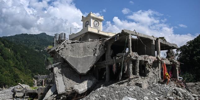
Rebuilding Nepal’s mountain roads in the exact same footprint after a glacial lake outburst flood or landslide is not "resilience." It is a subsidy for the next catastrophe.
Look at the standard post-disaster script. Officials stand in front of washed-out asphalt, use dramatic phrases like "tsunami of the mountains," and declare that they will not rebuild identically. Then, two budget cycles later, the concrete goes right back where the river—or the moraine wall—just proved it can reach. Read more on a related topic: this related article.
The headline logic sounds sensible at first glance. If you rebuild a road along a vulnerable valley floor or an active slope, people will cluster around it again. Markets form. Tea shops open. Homes cling to terraced edges because access equals livelihood. Move the road, and you supposedly break the magnet.
That argument has a kernel of truth. It also misses almost everything that actually drives exposure in the Himalaya. Further analysis by The Washington Post highlights similar perspectives on the subject.
Roads do not just bring settlers to danger. Roads are lifelines for remote valleys that have spent decades cut off from clinics, cold storage, emergency evacuation, and basic trade. Telling mountain communities to simply step back from the alignment without offering viable alternatives—or without fixing the upstream watershed and slope mechanics—is easy from a conference room in Kathmandu or Geneva. On the ground, people stay where water, flat-ish ground, and kin networks exist.
I have spent years working on infrastructure projects across steep, geologically active terrain where budgets evaporate into slope stabilization and emergency repairs. Watching multi-million-dollar corridors get chewed up season after season teaches you a brutal lesson: concrete does not negotiate with a destabilized mountain. When a glacial lake breaches a terminal moraine or monsoon rain saturates fractured Himalayan rock, standard engineering manuals look like wishful thinking.
What People Actually Mean by a "Mountain Tsunami"
Before talking about rerouting roads, we need to be exact about the physics. A glacial lake outburst flood—often shortened to GLOF—is not an ocean tsunami. An ocean tsunami is a long-wavelength wave driven by displacement of massive water columns across deep basins. A GLOF or debris flow in a narrow Himalayan gorge is a violent, sediment-choked surge of water, boulders, ice, and torn-up forest moving down a steep, confined channel.
The distinction matters because the failure modes are completely different. An ocean wave loses energy as it spreads or runs up a gentle slope. A high-gradient mountain debris flow acts almost like a dense fluid battering ram. It scours channels, undercuts toe slopes, buries bridges in meters of gravel, and turns a quiet stream into a wall of rock in minutes.
If you treat that hazard like a simple localized flood that a taller retaining wall can handle, you design for the wrong physics. Gabion baskets and standard masonry walls have their place in minor slope protection. Against a high-energy debris surge or a deep-seated rotational landslide triggered by intense monsoon downpours and seismic shaking, they are speed bumps.
The Lazy Consensus on "Not Rebuilding Identically"
Every major disaster produces a wave of pious commitments to "build back better." In Nepal, where steep relief, active tectonics, rapid glacier retreat, and intense summer monsoons collide, that phrase gets stretched thin.
The lazy consensus goes like this: The old road was hit because it hugged the river or crossed an unstable slope. Therefore, the fix is simply to shift the alignment or avoid building near it.
Why is that incomplete? Three reasons stand out.
First, geography in Nepal is unforgiving. A narrow river gorge is often the only grade-feasible corridor through rugged topography for tens of kilometers. Pushing a road higher up the valley wall frequently means cutting into steeper, more fractured rock slopes—which can trigger larger landslides than hugging the valley floor. Moving away from the river does not automatically mean moving to safety. Sometimes it just trades flood exposure for rockfall and slope failure exposure.
Second, settlement follows economic gravity, not just pavement. Even if planners push a highway alignment onto a higher ridge or across a valley, settlements already exist along old trails, river terraces, and agricultural pockets. Where roads go, transport costs drop and market access rises. People respond rationally to economic incentives. Scolding communities for building near roads ignores why they build there: proximity to transport lowers the cost of moving produce, buying fertilizer, reaching hospitals, and sending kids to school.
Third, a road network is a system, not a single line. A single washed-out bridge or blocked cliff section can isolate an entire district. Focusing solely on where one segment sits misses redundancy, bypasses, trail and ropeway links, early warning systems, and local maintenance capacity. If you reroute a main trunk road into a new alignment without building redundant spurs or local access, a single failure on the new line still severs the valley.
Why People Keep Asking the Wrong Questions
When disaster strikes high-mountain corridors, public debate usually fixates on two questions:
- Should we rebuild the road in the same place?
- How do we stop people from living in hazardous zones?
Both questions frame the problem too narrowly.
The better question is: What level of risk is acceptable for which function, and how do we design infrastructure that bends, drains, and recovers rather than pretending it will never be hit?
Consider a "People Also Ask" style question that pops up after every major mountain washout: Why do governments keep rebuilding roads in landslide and flood zones?
The blunt answer is political and practical, not just bureaucratic laziness. Rebuilding along an existing corridor is faster to survey, easier to get right-of-way for, and politically visible. Acquiring new land, conducting fresh geotechnical investigations across complex terrain, navigating environmental clearances, and convincing local communities whose land or livelihoods are affected takes years. Meanwhile, residents need food, medicine, and transport now. Short-term urgency routinely beats long-term risk reduction.
Another common question: Can engineering completely protect mountain roads from glacial floods and landslides?
No. Not in the Himalaya. You are dealing with some of the highest relief on Earth, active fault systems, fragile geology, warming temperatures reshaping high-altitude lakes, and extreme monsoon bursts. Zero risk is a fantasy. Pretending you can engineer total immunity leads to over-designed, under-maintained structures that fail catastrophically when an extreme event exceeds design thresholds.
What Heavy Hitters in Geohazards and Risk Actually Emphasize
Researchers and practitioners working on Himalayan geohazards—such as institutions like the International Centre for Integrated Mountain Development (ICIMOD), alongside geotechnical and disaster-risk researchers studying Nepal's cryosphere and hillslope hazards—have spent years pointing out how compound hazards interact. A warming climate thins glaciers and expands glacial lakes; earthquakes fracture rock masses; monsoon rains saturate slopes and mobilize debris.
The takeaway from serious geohazard work is not a single silver bullet like "move the road." It is multi-hazard risk management: mapping hazard runout zones rather than guessing from past high-water marks, monitoring upstream glacial lakes and unstable slopes, pairing physical protection with land-use planning, and investing in maintenance before cracks become collapses.
A Thought Experiment on Corridor Design
Imagine a scenario where planners are tasked with restoring a vital mountain link connecting an upper valley agricultural hub to a lower market town after a major debris flow wipes out three kilometers of valley-floor road and two bridges.
If they simply pour new asphalt along the same river edge, the next big surge takes it out again—and settlements creep back onto freshly deposited gravel bars that look flat and inviting but sit directly in the flood path.
Now imagine a different approach. Instead of treating the corridor as one rigid concrete ribbon, planners combine:
- Corridor-wide hazard zoning that identifies where debris flows and landslides actually run out, keeping permanent public buildings and dense settlements out of high-velocity channels.
- Sacrificial or modular crossings in hyper-active reaches where full rigid bridges get hammered—designs that can be cleared and restored faster, paired with sturdy, better-sited alignments where rock and topography genuinely allow higher ground.
- Decentralized local connectivity—improved feeder tracks, suspension bridges, and local storage—so a single break on the main artery does not starve upper villages.
- Early warning and maintenance funding tied to routine drainage clearing, because blocked culverts and unmaintained drainage cause a staggering share of everyday road failures long before a headline-grabbing disaster hits.
That approach is harder. It requires coordination across ministries, local governments, engineers, and residents. It does not produce a neat one-line slogan.
The Downsides of Playing It Contrarian
Being contrarian about mountain infrastructure comes with real trade-offs, and honesty requires naming them.
First, relocation and land-use restrictions carry heavy social costs. Moving people or restricting building near transport corridors can disrupt livelihoods, break community ties, and hit poorer households hardest if compensation is slow or inadequate. Top-down resettlement has a grim track record when done without genuine local participation and economic alternatives.
Second, rerouting can blow up costs and timelines. Shifting a mountain alignment often means steeper gradients, rock blasting, environmental trade-offs, and thorny land negotiations. A project stalled for five years leaves communities isolated today in exchange for theoretical safety tomorrow.
Third, better engineering and zoning do not eliminate extreme tail events. Even well-sited corridors and monitored basins face rare, massive events that overwhelm defenses. Anyone selling a "flood-proof" or "landslide-proof" mountain highway is selling fiction.
Practical Steps That Actually Move the Needle
If you care about keeping mountain communities connected without feeding the cycle of destruction, skip the slogans and focus on what works in rugged terrain:
- Map the hazard, not just the last disaster. Use geomorphology, historical event records, and remote sensing to identify debris channels, old landslide scars, and unstable toe slopes—not just the exact meter where water reached last time.
- Separate road access from unrestricted settlement. Pair transport planning with clear local zoning and safer buildable sites so new homes and shops do not automatically crowd into active floodplains and slide paths.
- Fund drainage and routine maintenance like your life depends on it. In steep terrain, water management makes or breaks roads. Clear ditches, functional culverts, and rapid post-monsoon repairs prevent small slides from becoming total washouts.
- Build redundancy into remote networks. Do not bet an entire valley's survival on a single fragile river crossing when secondary routes, trails, and local storage can cushion shocks.
Mountains do not care about our rebuild schedules. Build with the terrain's reality, or pay for the same mistake twice.


