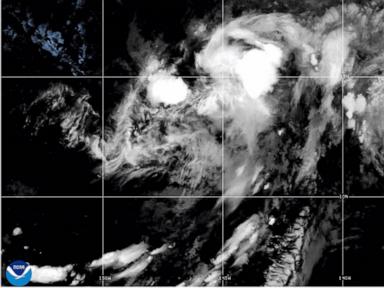
When a tropical storm trajectory shifts toward the Hawaiian archipelago, the immediate public discourse focuses almost exclusively on wind speeds and rainfall accumulations. This meteorological reductionism misses the operational reality of island supply chain fragility and geographic isolation. Tropical Storm Lala approaching the Big Island of Hawaii is not merely a weather event; it represents an acute stress test on an isolated import-dependent node where geographic barriers compound emergency response friction. Analyzing this scenario requires stripping away sensationalized media framing to examine the structural mechanics of island disaster preparedness, maritime supply chain vulnerability, and microclimate hazard exposure.
The Geography of Risk on the Big Island
The Island of Hawaii presents unique topographical hazards that standard meteorological alerts fail to operationalize for the civilian population. Spanning over four thousand square miles with active volcanic massifs exceeding thirteen thousand feet, the island creates localized atmospheric conditions that distort regional storm tracks and precipitation distribution.
When a cyclonic system approaches from the eastern Pacific, the windward and leeward dynamics dictate vastly different operational exposures. Windward sectors such as Hilo absorb persistent orographic rainfall, turning steep slopes into immediate saturation zones prone to mass wasting events. Conversely, leeward zones like Kona face severe down-slope wind acceleration and flash flooding driven by localized convective cells trapped against the western slopes of Mauna Loa and Hualalai.
The core operational vulnerability lies in inter-district connectivity. The island relies heavily on a limited number of arterial coastal highways, specifically sections of Route 19 and Route 11. These corridors cross historical lava flow fields and low-lying coastal ledges that possess zero redundancy. A single storm-induced washout at a critical gulch or coastal shelf completely severs communication and logistical support between East and West Hawaii, effectively fragmenting a single county-sized jurisdiction into isolated response pockets.
The Logistics Deficit of Isolated Island Economies
Emergency planning models designed for continental landmasses assume continuous supply lines and rapid intermodal freight rerouting. Hawaii violates every assumption of continental logistics continuity. The state imports approximately ninety percent of its food supply and essentially all of its refined petroleum products.
Ocean freight is the primary artery of survival. Commercial container ships moving through maritime hubs such as Honolulu and Hilo operate on tight, highly optimized inventory-to-sales ratios. When an approaching tropical storm triggers port closures, the maritime supply chain halts instantaneously.
The Inventory Buffer Breakdown
- Retail Stockpiling Velocity: Consumer panic buying compresses standard retail replenishment cycles from days to hours, exhausting local warehouse safety stocks before the storm makes landfall.
- Fuel Reserve Constraints: While storage facilities maintain baseline mandates, localized power grid failures at bulk distribution terminals immediately impede the high-speed pumping required to refuel municipal and emergency vehicle fleets.
- Airfreight Bottlenecks: Commercial aviation halts concurrently with high winds. Air cargo capacity becomes restricted exclusively to high-priority federal response payloads, cutting off private sector replenishment vectors.
This creates a rigid window of self-sufficiency. Without proactive municipal staging protocols implemented seventy-two hours prior to wave and wind thresholds being met, municipal response agencies transition from managed mitigation to reactive triage within twenty-four hours of port closure.
Power Grid Vulnerability and Decentralization Failure
Utility infrastructure across the Big Island reflects a radial transmission architecture rather than a hardened mesh network. Power distribution relies on long transmission lines traversing dense tropical forests and rugged terrain subject to high tree-fall density during tropical storm force gusts.
When winds exceed forty miles per hour, structural failures in vegetation management zones cause cascading feeder trips. The loss of centralized power generation immediately compromises three critical interdependent systems:
- Potable Water Distribution: Municipal wells and booster pumps require continuous electrical input. Backup diesel generators exist at primary facilities, but extended grid outages exhaust onsite fuel supplies within days if fuel delivery trucks cannot navigate blocked rural routes.
- Communications Backhaul: Cellular towers rely on local grid power with limited battery backup. Once battery reserves deplete, localized telecommunications blackouts isolate rural communities, preventing damage assessment reporting from reaching county emergency operations centers.
- Cold Chain Integrity: Supermarkets and medical facilities experience immediate thermal decay of perishable inventories and temperature-controlled pharmaceuticals, compounding public health risks long after the meteorological hazard dissipates.
Operational Protocol for Systemic Resilience
Managing tropical storm exposure in an isolated maritime environment requires shifting from reactive disaster relief to continuous structural stress-testing. Emergency management frameworks must abandon generalized evacuation alerts in favor of targeted infrastructure hardening and decentralized resource pre-positioning.
First, logistics planners must treat inter-island maritime disruptions as a permanent baseline constraint. Maintaining a decentralized reserve of non-perishable staples and water purification units within each distinct geographic district bypasses the single-point-of-failure vulnerability of central warehouses dependent on coastal highway transit.
Second, microgrid integration for critical municipal infrastructure must accelerate. Pairing water treatment plants and emergency shelters with solar generation and localized battery storage ensures operational continuity during extended transmission line failures.
Finally, municipal authorities must enforce stricter vegetation clearance mandates along all primary transmission and evacuation corridors. Mitigating the risk of vegetative blow-downs preserves roadway clearance speed, enabling rapid emergency medical services deployment and damage triage before secondary compounding hazards materialize. The true measure of preparation for Tropical Storm Lala is not the wind speed recorded at the coastline, but the operational latency of the systems designed to restore baseline function after the wind subsides.


